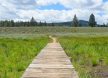
Distance: 13.4 miles round trip Elevation Change: 7000 ft. to 7760 ft. Hiking Watson Lake Trail: Casual hikers love Watson Lake for it’s beauty and seclusion. It is a perfect site for a picnic and swim with gorgeous views, wildflowers, and small... More Details

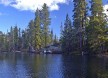
The Desolation Wilderness is located in the Crystal Range of the Sierra Nevada mountains. Covering 63,960 acres west of South Lake Tahoe and north of Highway 50 in El Dorado County, the Wilderness offers stunning alpine lakes, granite peaks, and glacially... More Details
Technical Level: Beginner Mountain Bikers and Hikers Elevation Gain: Around 1,700′ The Ride: 15 miles one way (trail loops back) Location: Truckee, CA Season: Late Spring/Summer This is Truckee’s most popular mountain biking trail, but is... More Details

Length: 1 mile loop Terrain: flat dirt trail Nestled among alpine peaks of Truckee, the Glenshire Lake loop is relaxing and simple to navigate, making it perfect for families with young children. This area has lots of gently rolling hills and gorgeous... More Details
Difficulty: Moderate Elevation: 7000′ / 8000′ Mileage (one way): 5 miles Directions to Trailhead: Park at the Spooner Lake Trailhead, located in Lake Tahoe Nevada State Park, just northwest of the Highway 50 / 28 junction. A parking fee is... More Details
Difficulty: Moderate Elevation: 6240′ / 8880′ Mileage (one way): 4.5 to 8 miles Trail: This moderate hike takes you along the northern most part of the unofficial Tahoe-Yosemite Trail. After following a road for approximately 1.3 miles, the... More Details
Difficulty: Difficult Elevation: 8700′ / 10778′ Mileage (one way): 6 miles Directions to Trailhead: Take Highway 431 (Mt. Rose Highway) north of Incline Village. Park at the trailhead located one mile south of the summit. Trail: Follow a... More Details
Difficulty: Easy Elevation: Flat Mileage (one way): No designated trail Directions to Trailhead : From Highway 89, two miles south of Tahoe City, turn on Pineland Drive. Turn right on Forest Service Road 15N60 or 16N48 to get to the area. Trail... More Details
Difficulty: Easy Elevation: 6200′ / 6800′ Mileage (one way): 1.5 miles Directions to Trailhead: Take Highway 28 from Highway 50 north approximately 2 miles. Look for an iron pipe gate on the west side of the highway. Park in one of the turnouts... More Details
Difficulty: Moderate Elevation: Varies by route Mileage (one way): 2 to 12 miles Directions to Trailhead: Take Highway 50 east approximately 1/2 mile from the junction of Highway 50 and 28. Parking is located just beyond Spooner Summit along the north... More Details
Length: 9 mile loop Elevation Gain: 500 feet Terrain: single-track, smooth dirt, some scree deposits This adventure takes mountain bikers, runners, and day-hikers along the ridge between Squaw Valley and Northstar ski resorts. Many Truckee local’s... More Details
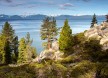
Distance: 12.2 miles Highlights: Panoramic Views of Lake Tahoe, Ancient Firs Trailheads Spooner Summit South: On S side of Hwy 50 just west of summit. Trailer parking available. Vault toilets, picnic tables. Kingsbury North: From Hwy 207 just W of summit... More Details
Difficulty: Easy Elevation: 7014′ Mileage (one way): 0.5 miles Directions to Trailhead: From Highway 28 on the north shore of Lake Tahoe, turn north on Reservoir Drive just east of the old Tahoe Biltmore Casino. Turn right on Lakeshore Avenue and... More Details
Multiple Trails Difficulty: Easy Elevation: Flat Mileage (one way): Vary per trail Sugar Pine Point State Park Hiking and Nature Trails Explore the many trails that wind their way through this park’s awe-inspiring forest of sugar pine, aspen, juniper,... More Details
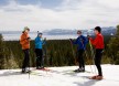
Winter at Tahoe XC Discover serene meadow trails, challenging hills, and a few thrilling downhill areas at Tahoe XC in Tahoe City. The setting is ideal for cross country skiers and snowshoeing enthusiasts of all abilities. Its 22 trails, spanning more... More Details